Map Skills Worksheets
- Social Studies >
- Map Skills
Upgrade your kids' navigation skills with our free, printable map skills worksheets. Help improve the budding geologists' spatial awareness and promote analytical thinking among them. Featuring a mélange of maps, these exercises help children understand places, spaces, and scales better, laying a solid foundation for more advanced concepts in geography in the process.
These map skills worksheets pdf are recommended for children in grade 1 through grade 5.
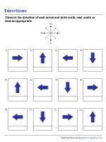
Introduce 1st grade and 2nd grade kids to the concept of directions using the points of a compass, and prepare them to read maps of all kinds with ease using these worksheets.
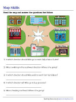
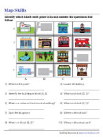
A bakery, a boutique, a drugstore, and a diner are some of the places marked on this map of a neighborhood. Encourage kids to employ spatial thinking and answer this exercise.
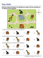
Interpreting an Animal-Themed Map
Animals expertly captain the ship, as grade 1 and grade 2 children fall back on their grasp of cardinal directions to answer a set of questions in this printable map skills worksheet.
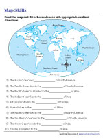
Answering Questions Based on a World Map
Featuring a map of the world, this map skills worksheet pdf gets grade 3 and grade 4 kids completing sentences on the locations of oceans and continents relative to one another.
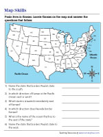
Little Paula lives in Kansas. Help her know more about her neighboring states using the US map in this exercise. Make sure you don't let your focus stray far beyond the indicated state.
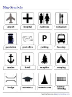
Cartographic symbols take center stage in this part of our map skills worksheets pdf with exercises on map symbols, their meanings, and the ways kids can use them to read maps.
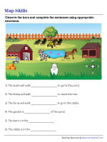
Interpreting the Map of a Farm
A farm, awash with natural splendor, is the subject of this map. Instruct 3rd grade and 4th grade kids to figure out the directions where the different buildings lie, relative to one another.
Infuse variety in map time with this exercise that tasks kids with locating different places using an alphanumeric grid. Keeping an eye on the row and column labels is the key here.
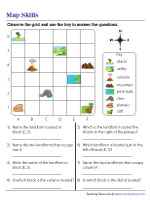
Locate the landforms on the alphanumeric grid and answer the questions that follow. Observe the horizontal and vertical axes, keeping an eye on the name of each block.
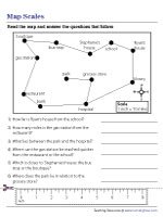
Teach budding geologists how to interpret maps and estimate distances using a cartographic scale, the ratio between map and actual distances, in this section of our printable map skills worksheets.
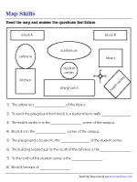
Explore the length and breadth of a school campus in this pdf, where the task is for 5th grade children to answer questions on the directions of buildings such as the library and the health center.